


Mallorca Topo Maps
Opis aplikacije Mallorca Topo Maps
+++ Нова ГПС мапирање апликација +++
Лако се користи на отвореном / Ван ГПС навигациони апликацију са приступом најбољим топографских карата и аеро снимака за Маллорца.
++ За употребу ван ПРО функција потребна! ++
Претворите свој Андоид телефона / таблета у отвореним ГПС за путовања исувише забити БЕЗ ЦЕЛЛ покривеност. Ова апликација вам даје сличне опције мапирање Као што можда знате из Гармин или Магеллан ГПС ручне.
Укључен Фрее Мап слојева:
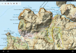
• Мајорка Топо Карта: Карта Топографицо Насионал 1: 50.000 и 1: 25.000 (ИГН МТН25 & МТН50)
• Мајорка База Карта: ИГН База Топографица Насионал 1: 25.000 (БТН25 & БЦН25)
• Мајорка снимци: Висока резолуција слике из ваздуха. План Национал Ортофотографиа Аереа (ПНОА)
• зк Карта: цартографиа Кадастровиј
• опен стрит мап: Ове Краудсорсовани мапе су веома користан додатак другим карте слојева. Садржи многе јединствене карактеристике.
• ОпенЦицлеМапс: Ове мапе су идеални за планирање бициклистичких путовања
• ЕСРИ топографски
• ЕСРИ Радне слике
• ЕСРИ Стреет Мап
• Гоогле Мапа пута (на мрежи приступ само)
• Гоогле Сателлите Слике (онлајн приступ само)
• Гоогле терена Карта (онлајн приступ само)
• Бинг Мапа пута (на мрежи приступ само)
• Бинг сателит слике (онлајн приступ само)
• Земља Ат Нигхт
• Хиллсхадинг преклапање
Главне карактеристике за вањску-пловидбе:
• Стварање и уређивање путне тачке
• Гото-Ваипоинт-Навигација
• трацк рецординг (брзином, надморске висине и тачности профила)
• Трипмастер пољима за километражу, просечна брзина, имајући, надморска висина, итд са
• ГПКС / КМЛ / КМЗ Извоз
• Тражи (Плаценамес, ПОИ, улице)
• Прилагодљиви датафиелдс у мапе и Трипмастер (нпр брзине, Удаљеност, Компас, ...)
• Делите Ваипоинтс, траке или Руте (путем е-маила, ВхатсАпп, Дропбок, Фацебоок, ..)
• Приказ координира у Лат / Лон, УТМ или МГРС / УСНГ (Војна Мрежа / САД Натионал Грид)
• Снимање и делите нумере са статистиком & Елеватион Профиле
• Ротација мапа (Трек Горе и Северна уп)
• Гет надморску висину дуго кликните на мапу
• Трек Реплаи
• и још много тога ...
Доступне Про карактеристике: (Про карактеристике су доступни преко У Апп Пурцхасе)
• Ван Користи - не покрива ћелија потребан
• Лако + Фаст Масовно преузимање на карте плочица за Вне употребе (не за Гоогле и Бинг мапс)
• Креирање и измена Руте
• маршрута Навигација (Поинт-то-Поинт Навигација)
• ГПКС / КМЛ / КМЗ Увоз
• неограничена Ваипоинтс & Тотал
• Додајте остале карте Тиле-Сервер
• Но Адс
Оффлине Употреба:
Све приказане мапе плочице се чувају у кешу. Да кешира велике површине које су вам потребне за куповину Про функције.
Користите ову навигацију апликацију за активности на отвореном, као што су планинарење, бициклизам, камповање, пењање, јахање, скијање, кану, лов, оффроад 4ВД туре или тражење и спашавање (САР).
Додај прилагођене тачака у дужини / ширини, УТМ или МГРС / УСНГ формату са ВГС84 датум.
Увоз / извоз / Подели ГПС путне тачке / Трацкс / Руте у ГПКС или Скини / КМЗ формату.
Прелоад Фрее Мап податке за подручја без ћелија службе (Про функција!).
Коментари и захтеве за маллорцамапс@атлогис.цом
Да погледамо наше друге отвореном за навигацију апликације: хттпс://плаи.гоогле.цом/сторе/сеарцх?к=атлогис
+++ Ми не прате било какве активности корисника или прикупити све податке корисника! +++
Mallorca Topo Maps - Verzija 7.7.2
(22-03-2025)Mallorca Topo Maps - Informacije o APK datoteci
Verzija APK datoteke: 7.7.2Paket: com.atlogis.mallorcaPoslednja verzija aplikacije Mallorca Topo Maps
Druge verzije


 3.64
3.64

Aplikacije u istoj kategoriji

Možda će vam se takođe dopasti i...


